Cumulative Impacts Rulemaking
The Minnesota Pollution Control Agency (MPCA) is developing a new rule to better protect communities that experience disproportionate exposure to pollution. The Cumulative Impacts Rule is intended to ensure permitting decisions consider not only a facility’s individual emissions but also will require MPCA to consider the cumulative impacts of pollution, such as environmental and social stressors, during the permitting process.
The MPCA began drafting this rule in 2023 and has since held information sessions, public comment periods, and webinars to gather feedback regarding the proposed rule. Details regarding the rulemaking process are shared on the MPCA’s Cumulative impacts rulemaking page. Through these meetings, the MPCA is continuing to refine the criteria to determine when a cumulative impact analysis is required and what a cumulative impact analysis would entail when permitting.
The MPCA shared a few details of the draft Cumulative Impacts rule at the Conference on the Environment, held on November 6, 2025. The rule will apply to facilities within the 7-county metro area, Duluth, and Rochester, upon taking a permitting action. Under the draft framework, applicants at affected facilities must incorporate a cumulative impacts analysis into their permitting applications. It is not clear what the analysis will entail, nor is it clear if there will be exemptions available. If the initial cumulative impacts analysis does not yield passing results, the permitting project will either not move forward, the analysis will require refinement, or the project will require a community benefit agreement to be reached with the local community, the agency, and the permittee prior to proceeding with the project.
The MPCA has a deadline of May 18, 2026 to publish the draft rule text in the State Register.
Cumulative Impacts Map
In support of the Cumulative Impacts Rule, the MPCA has drafted a Cumulative Impacts Mapping and Analysis Platform. The goal of the tool is to visualize what environmental and social factors affect different areas, as well as how many different factors are present at “Above Threshold” levels in a location. The tool is still in the draft phase, meaning that some of the technical guidance, contact information, and language translations are not available yet.
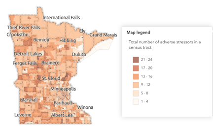
The Cumulative Impacts Map is navigated by scrolling within interface map or by inputting an address into the search bar. Once the location is chosen, different layers can be toggled on and off, including reference layers, air pollution, land pollution, water pollution, traffic factors, social factors, public health factors, and neighborhood factors. It should be noted that each layer is independent and cannot be displayed in a combined view (for example, a user could not view both the cumulative impacts summary layer and the traffic density layer).
Unfortunately, the draft Cumulative Impacts Map tool does not specify if a location will be subject to further review under the Cumulative Impacts Rule (as of the date of this article). Users can identify the number of adverse stressors that affect a location (for example – the Trinity Office in Woodbury, MN is in a location with 13 stressors). The tool also compares the location’s stressor total against state and county’s median stressors. Keeping with the Trinity Office example, Washington County has a median of 12 adverse stressors, while Minnesota has a median of 14 adverse stressors. However, the map does not specify what the individual stressors are, or if the location would be subject to the Cumulative Impacts Rule. If the user wants to identify individual stressors, they must navigate through each layer option and determine if the threshold for each layer is exceeded in the relevant location.
The Cumulative Impacts Map can display MPCA air permitted facilities (for Part 70 permits and state permits). Other permitted sites and agency interests (such as Hazardous Waste Generator Status) do not show up on the map. This data is present in MPCA’s What’s in my Neighborhood tool, however, it is not clear if this data will be pulled into the Cumulative Impacts Map as an individual layer. Further, the agency verbally identified environmental justice areas being key to the applicability of the Cumulative Impacts Rule. Environmental Justice areas can be identified on a separate EJ areas map tool, but there is no current option to view Environmental Justice areas as a layer on the Cumulative Impacts tool.
Trinity anticipates MPCA’s technical guidance document for the Cumulative Impacts Map will provide greater clarity on the tool and how to best utilize it efficiently.
Upcoming Trinity Webinars
Trinity is looking forward to reviewing the MPCA’s upcoming rulemaking for both the Cumulative Impacts Rule and the Air Toxics Rule. Webinars on the state of both rules will be scheduled for early Summer of 2026 to discuss the draft regulations.
If you have questions around the Cumulative Impacts Rule, Trinity is available to support. For more information on this topic, please contact Jena DeRung by email or Trinity’s Minneapolis office at 651.275.9900.
